Every week, News 12 examines America's critical infrastructure as experts and leaders sound the alarm over deficiencies in 'Failing Foundations' - A News 12 special report.
VIDEO: TRI-STATE DAM DANGERS
A startling Team 12 investigation has found that tens of thousands of people are living downstream from dams that are in danger of creating life-threatening floods if repairs are not made.
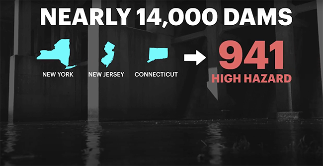
There are more than 10,000 dams in New York, New Jersey and Connecticut - and about one-third of the ones that could cause the most damage are at risk of failing.
News 12 focused on the 941 dams considered a "high hazard" because people would likely die if they failed.
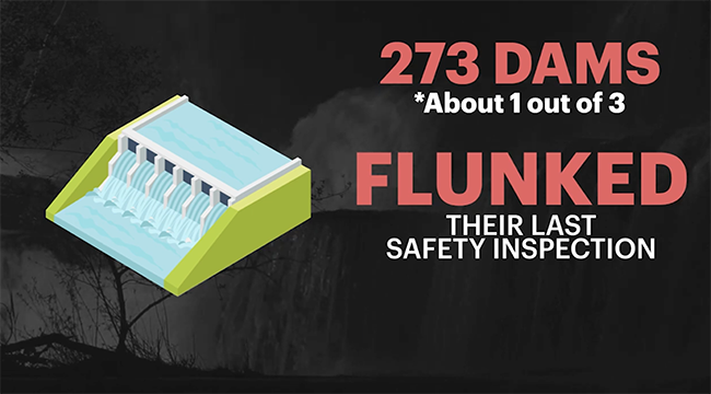
The investigation, which analyzed state and federal data, found that 273 of them - about one out of every three - flunked their last safety inspection by receiving a rating of poor, unsound or deficiently maintained.
Unfortunately, people could die.
“Unfortunately, dams will fail and if there are people living downstream of them, businesses, schools, other things, unfortunately, people could die," says Mark Ogden, of the Association of State Dam Safety Officials. "Or, even when in a failure, where you have an emergency action plan and people are evacuated in time, the devastation downstream is immense.”
The Bowman Avenue Dam. Seven hackers tied to the Iranian government were charged in a series of punishing cyberattacks on dozens of banks and a small dams outside New York City. (AP Photo/Seth Wenig)
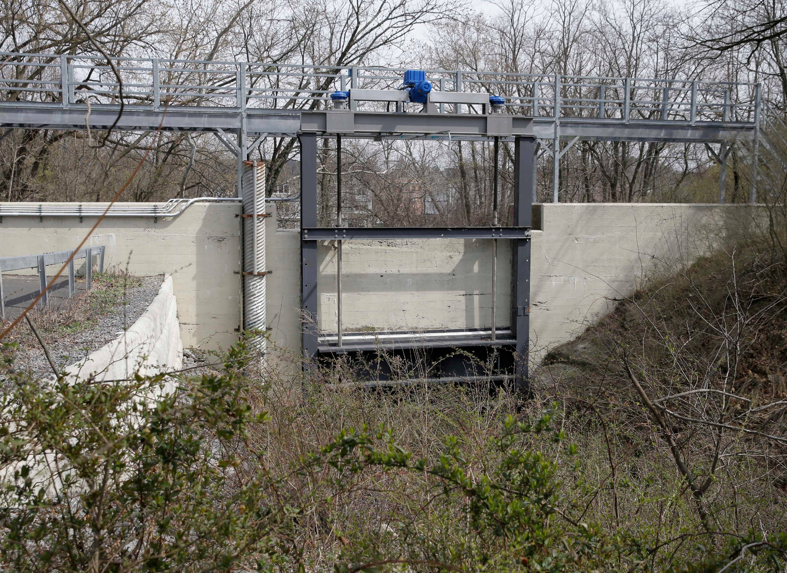
That's the case at the troubled Lake Sebago Dam in the Harriman State Park, where a breach would flood seven communities downstream in New York and New Jersey. Problems have been documented for more than a decade in one letter News 12 obtained from 2018.
I don't think people understand the power that is behind these dams. If that energy were to be released all at once that would be catastrophic.
A state engineer called the structure's inadequate spillway capacity "a serious issue," and warned that it does not meet the safety criteria for a high-hazard dam.
Top aquatic ecologist George Jackman warns that this is something that should not be taken lightly.
"I don't think people understand the power that is behind these dams. If that energy were to be released all at once that would be catastrophic," says Jackman.
News 12's review of open records also led to another alarming discovery. One out of every five New York dam owners legally required to file an emergency action plan, or EAP, with the state has failed to comply.
The Bowman Avenue Dam in Rye Brook is one of 209 dams in the state without a required EAP on file. However, that's not the reason the nearly century-old structure once made international headlines.
The small dam was caught up in an Iranian computer hacking case in 2013.
Greg McKenzie was hired to install a new computer at the site after the highly publicized hack, but says the dam remains vulnerable today and is still in a state of disrepair.
"It's a bad accident waiting to happen," says McKenzie.
The dam owners can be state governments, local governments or even a private individual. These entities are responsible for repairs, but they don't often have the money to fix them.
It's a bad accident waiting to happen.
New York State Comptroller Tom DiNapoli says the money included in the recently passed infrastructure bill will help, but it’s not enough.
"They have a 50, 70-year life and they have to be either rebuilt, repaired or removed," says aquatic geologist Jackman.
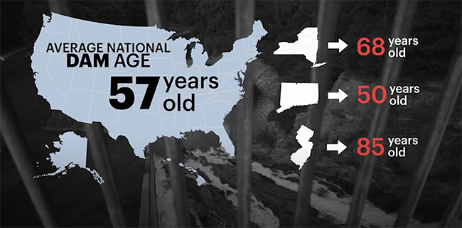
For example, the average age for a dam nationwide is 57, according to the American Society of Civil Engineers. In New York it's 68 years. In Connecticut it's 50 and in New Jersey it's 85 years.
"You can't ignore a dam. These are not stone walls in a forest you can just ignore," says Jackman.
Ignoring the problem could lead to painful consequences.
The American Society of Civil Engineers assigned the country a "D" grade on its dam infrastructure report card this year, a problem estimated to cost $20 billion to fix.
If you are concerned about the safety of your local dams, Tara Rosenblum wants to hear from you. You can find her on Facebook, Instagram and Twitter.
CRUMBLING CONDITIONS
If you take the train to work, you may be riding over bridges that are over 100 years old. Some of those bridges are in crumbling condition and have been neglected for years - one of the main reasons behind the frustrating delays and failures that impact commuters all over the Northeast.
TWO BRIDGES OVER A CENTURY OLD
Team 12 Investigates decided to look at two critical bridges that are over 100 years old. They both connect the entire Northeast and thousands of commuters that ride on them daily.
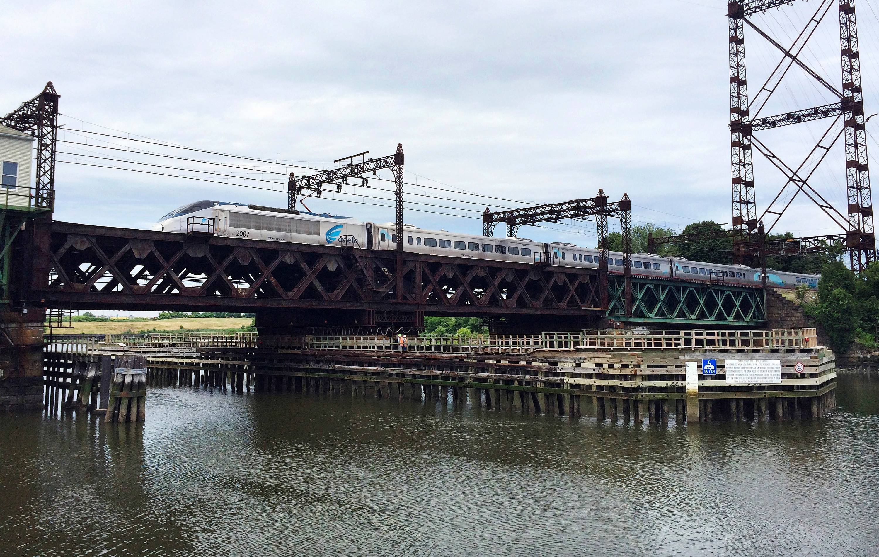
The Walk Bridge in Norwalk, Conn. is a 125-year-old draw bridge that was built in 1896 and later reconstructed in 1985. It's a four-track bridge that carries Amtrak and Metro-North passengers and is a critical link that connects Boston to Washington, D.C. Over 18,000 passengers travel over it, according to inspection reports.
In this June 20, 2018 file photo, Amtrak's Acela Express crosses the Norwalk River Railroad Bridge, also known as the Walk Bridge, in Norwalk, Conn. (AP Photo/Susan Haigh, File)
Transit officials call it safe, but in recent years, the bridge has failed mechanically when operators tried to open and close it. According to the Department of Transportation, the bridge failed 12 times in 2011, 16 times out of 271 openings and failed twice within a two-week period in 2014.
When the bridge fails, it causes all four tracks to be out of service and trains to be stuck and delayed. Amy Barrett, who was a passenger on a Metro-North train, tells News 12 she was stuck on the train for hours during a failure in 2016.
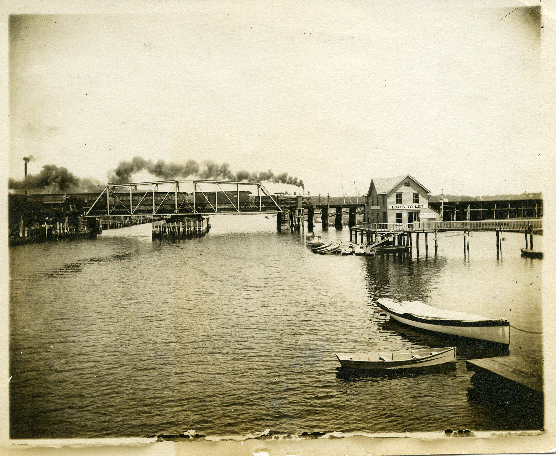
The original Walk Bridge in 1895 before construction located in South Norwalk, Conn (Norwalk History Room)
According to inspection reports, the bridge was found to be in poor condition in 2019, 2020 and 2021. A 2019 inspection report shows images of what they call "laminated rust," "section loss" and "misalignment". And in a separate report in 2019 the DOT wrote, "without action to rehabilitate or replace the bridge, failures are expected to increase".
The DOT commissioner tells us the state has patched up the problems for years and says it has taken so long to replace because of the impacts on the surrounding community, the need for permits and state and federal funding.
Without action to rehabilitate or replace the bridge, failures are expected to increase.
But help is finally on the way - as the Walk Bridge will be replaced this spring, pending certain permits. It also comes with a $600 million price tag and is fully funded for the replacement.
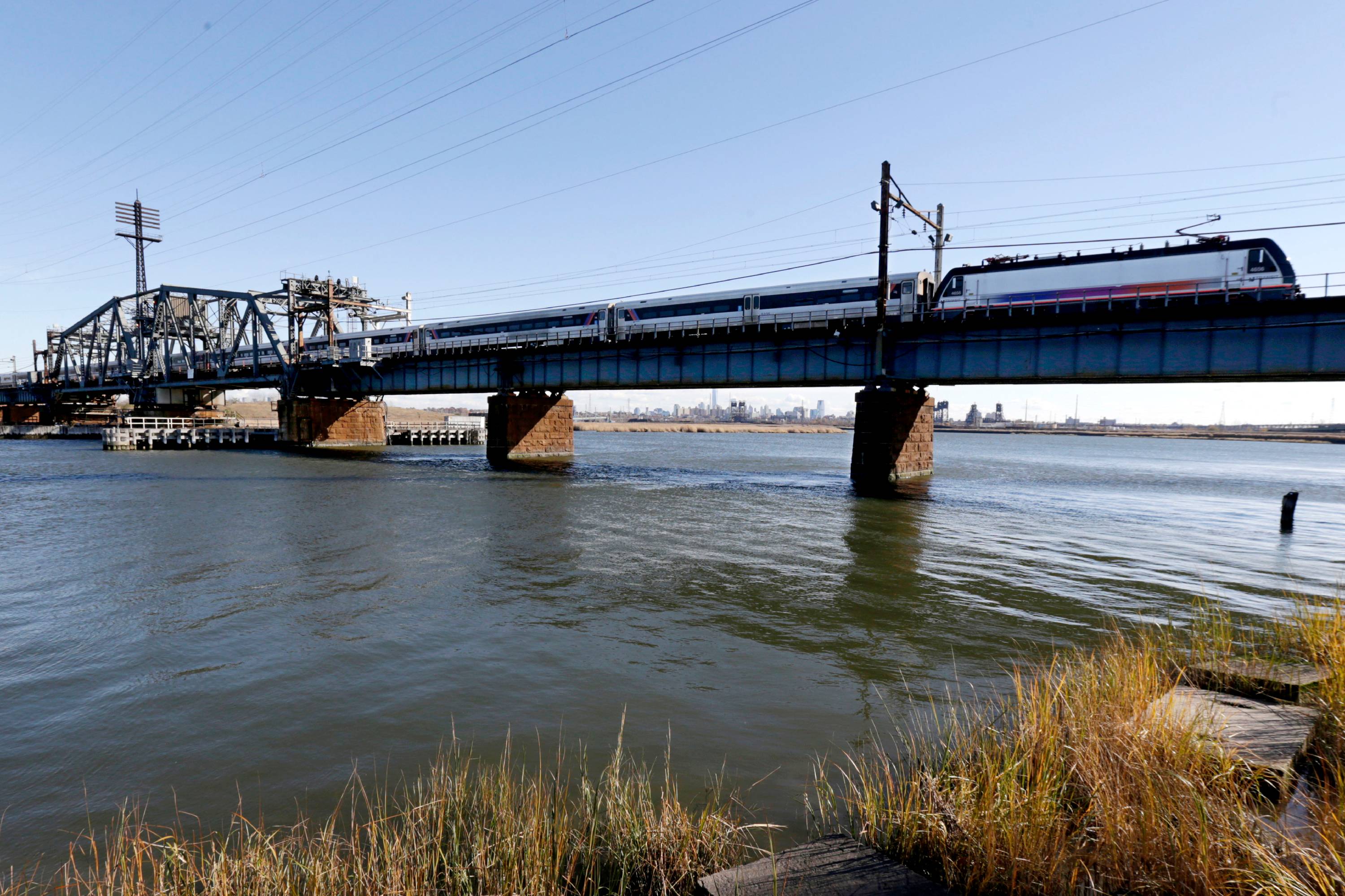
In this Nov. 14, 2014 file photo, a New Jersey Transit train crosses Portal Bridge in Kearny, N.J. (AP Photo/Julio Cortez, File)
News 12 also focused on the Portal Bridge in Kearny, New Jersey. President Biden recently visited the state, where he called the ageing bridge a "bottleneck" of the Northeast corridor. It's a 111-year-old draw bridge that transports 200,000 passengers daily for Amtrak and New Jersey Transit.
The two-track bridge causes significant delays when it fails to open and close for maritime traffic. In one of its reports, Amtrak even says "the aging Portal Bridge requires regular repairs to address malfunctions caused by outdated mechanical and electrical systems, often resulting in a cascade of delays.”
Amtrak also said bridge openings resulted in 230 delay hours and 1,000 train delays from 2014 to 2018.
Officials say the bridge has been neglected for years, but the Portal Bridge will cost $1.5 billion to replace. The project is funded through state and federal programs and grants. The replacement will be called the Portal North Bridge.
The aging Portal Bridge requires regular repairs to address malfunctions caused by outdated mechanical and electrical systems, often resulting in a cascade of delays.
It's a significant move to finally replace the deteriorated and ageing infrastructure, officials say. They hope this will be the catalyst to getting critical infrastructure back on track.
After President Biden signed the infrastructure package into law, the dozens of other structurally deficient bridges in the tri-state area may be eligible for the $40 billion allocation for funding for bridge repair, replacement and rehabilitation, according to the White House.
The Metropolitan Transportation Authority invested billions of federal funds into flood resiliency equipment after Superstorm Sandy - that it has never used.
None of it was deployed during Ida this past September, when videos of commuters wading through waterfalls inside the MTA surfaced all over social media.
The MTA installed 68 flex gates and 22 marine doors, each specifically fitted for different subway station entrances throughout the city.
Flex gates are tarp-like covers, which require at least 8 staff members to deploy, 10 minutes to install and at least eight to 10 hours to prepare for.
VIDEO: Timelapse of Subway Flex Gate Closure
Marine doors cover the entrance to a low-lying station. They weigh 2,000 pounds and are secured with 20 pounds of air pressure to cut off water from getting into the platform. Preparing to use a marine door also takes hours, the MTA says, because both flex gates and marine doors require the agency to evacuate the subway of staff and commuters.
VIDEO SLIDESHOW: Ida Overwhelms NYC's Infrastructure:
After Superstorm Sandy, the MTA targeted stations in coastal flood zones, which, generally speaking, means stations along the water:
•Lower Manhattan
•The Brooklyn and Queens waterfronts (Williamsburg to Long Island City)
•Parts of Upper Manhattan and the Bronx (along the Harlem River)
There are 33 “flood zones,” which don’t include above-ground stations.
A subway station that had earlier flooded remains closed after a state of emergency was declared in New York Thursday, Sept 2, 2021, as the remnants of Hurricane Ida remained powerful as it moved along the Eastern seaboard. (AP Photo/Craig Ruttle)
WHY CAN’T THE MTA USE THEM?
The MTA hasn’t used this equipment, our Team 12 Investigation found, largely because of timing and location of the gates.
The flex gates and marine doors were installed as a reaction to Superstorm Sandy, a deadly storm which brought water surging over the New York coastline. In response, the floodgates were installed where Sandy hit the hardest.
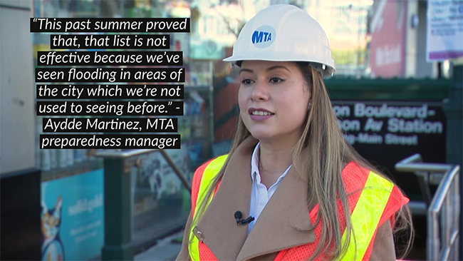
“This past summer proved that, that list is not effective because we've seen flooding in areas of the city which we're not used to seeing before,” says Aydde Martinez, the MTA preparedness manager.
When Ida hit New York City, the flash flood waters inundated the system in areas that didn’t have any flood resiliency doors installed. The doors were useless, our investigation found, against flash flooding.
Even if the MTA wanted to use the gates, it wouldn’t have mattered.
That, in conjunction with the unpredictability of flash-flood storms and the time it takes to install the gates while evaluating the subway, rendered much of the MTA’s existing flood technology unusable against Ida.
WHO PAYS FOR THIS?
After Superstorm Sandy, the MTA received $7.8 billion in federal funds to get the system ready for the next flood.
The agency still hasn’t spent all of it, with nearly $2 billion left in the bank. Officials have said the money is held up because of poor coordination from other agencies.
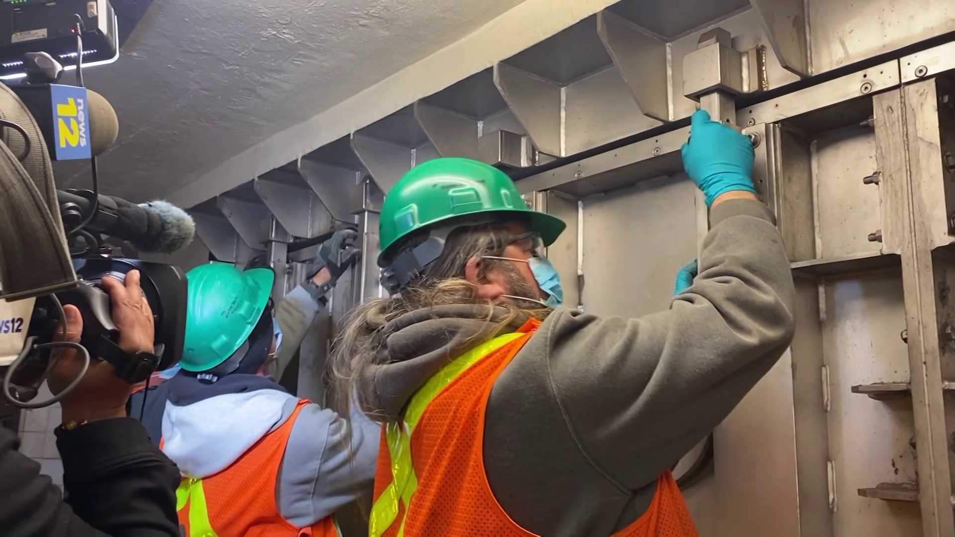
Workers initiate anti-flood measures in a New York City subway station. (Sabrina Franza/News 12)
NOW WHAT?
Today, the MTA stands to receive $10 billion in funding from the new federal infrastructure package.
The agency launched a task force to survey up to 160 new stations hit by flash flooding, working with the city’s Department of Transportation and the Department of Environmental Protection. However, our investigation found that they might not use the infrastructure money to pay for those flooding fixes.
The MTA tells Team 12 that it needs to work together with other agencies to make progress, to prevent the sewage system from overwhelming the subway and to fix streets so that water isn't getting pushed onto the platforms. They also told us that they expect to get even more money from FEMA to fix the issues.
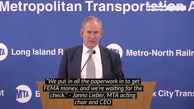
“We put in all the paperwork in to get FEMA money,” says Janno Lieber, MTA acting chair and CEO. “And we’re waiting for the check.”
Still, the MTA is left with flood prevention equipment only usable during one kind of flood -- a coastal storm surge, not flash flooding.
PAST THE BREAKING POINT
A Team 12 investigation finds increased flooding due to severe weather could cripple up to a third of roads, hospitals, mass transit and other critical infrastructure in the tri-state area, posing a growing threat to lawmakers who hope to upgrade the region’s “Failing Foundations”.
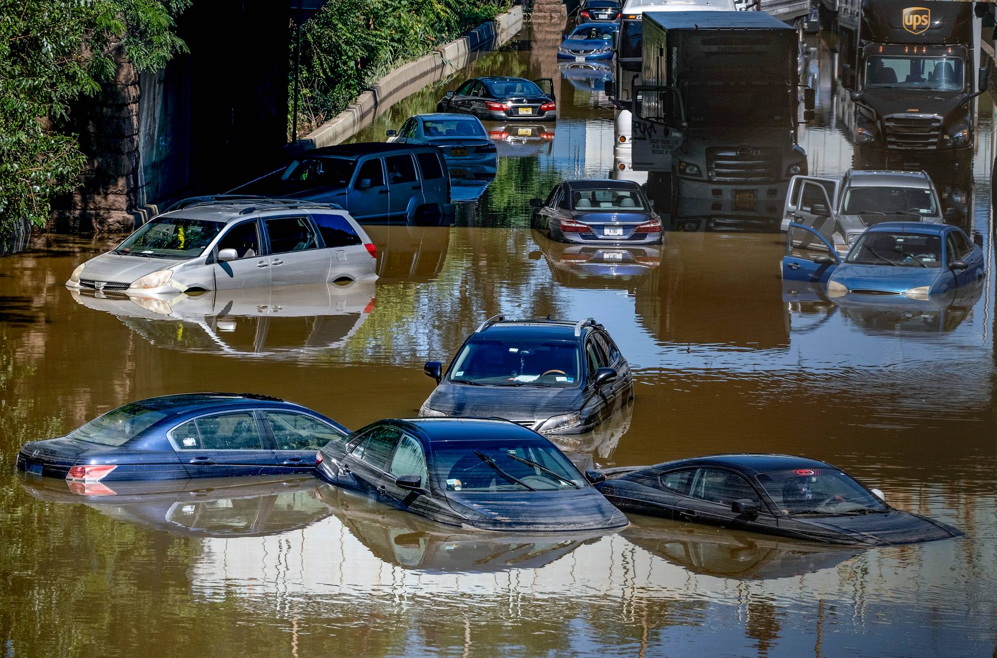
In September, New York City commuters captured video that almost had to be seen to be believed: subway stations so overwhelmed by flooding, straphangers had to brave water above their waists. The culprit: runoff from heavy rain, which pushed the MTA’s aging drainage system past its breaking point.
VIDEO SLIDESHOW: Ida's Aftermath
“The system only can take so much water at a time, so you have to expect this at times,” MTA employee Nicholas Brown told News 12 at the time.
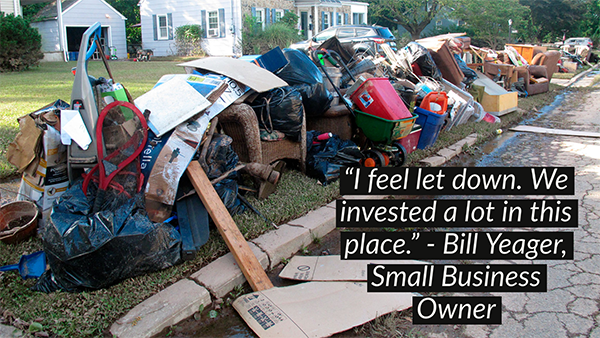
In Bound Brook, New Jersey, a $300 million flood control plan proved no match for the remnants of Ida. An NJ Transit train, stranded by high water, forced a floodgate to stay open, unleashing a deluge that swamped homes and small businesses.
General view of 206 partially flooded as a result of the remnants of Hurricane Ida in Somerville, N.J., Thursday, Sept. 2, 2021. (AP Photo/Eduardo Munoz Alvarez)
“I feel let down,” said small business owner Bill Yeager. “We invested a lot in this place.”
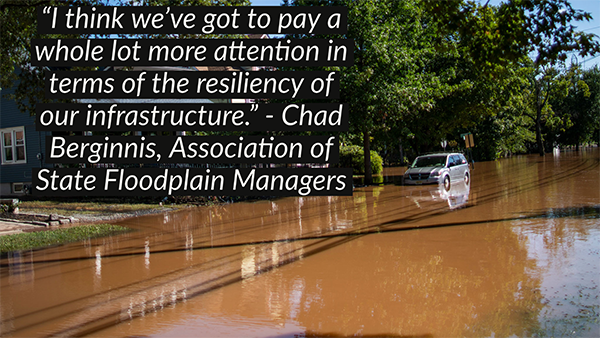
Incidents like this are becoming more common across the tri state area. From major highways like I-95 in Connecticut to first responders like the Glen Cove Police Department, vital infrastructure facilities are increasingly seeing operations disrupted by flooding.
I think we've got to pay a whole lot more attention in terms of the resiliency of our infrastructure,” says Chad Berginnis, executive director of the Association of State Floodplain Managers. “Those facilities have got to not only not flood, but be operational, and functionally operational during these kinds of flood events.”
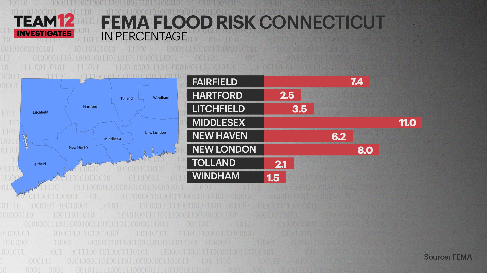
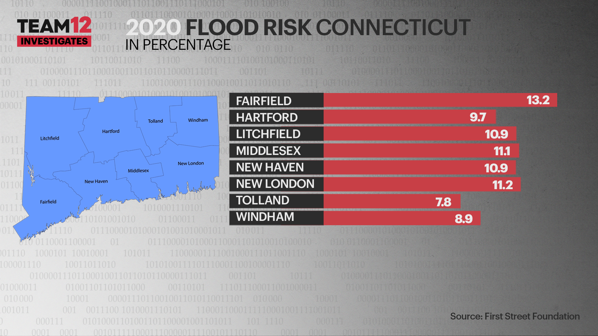
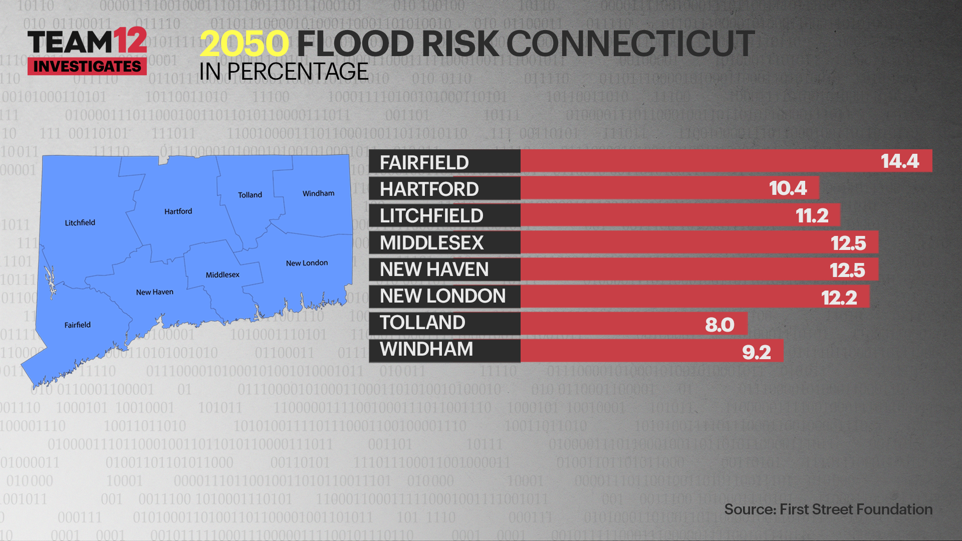
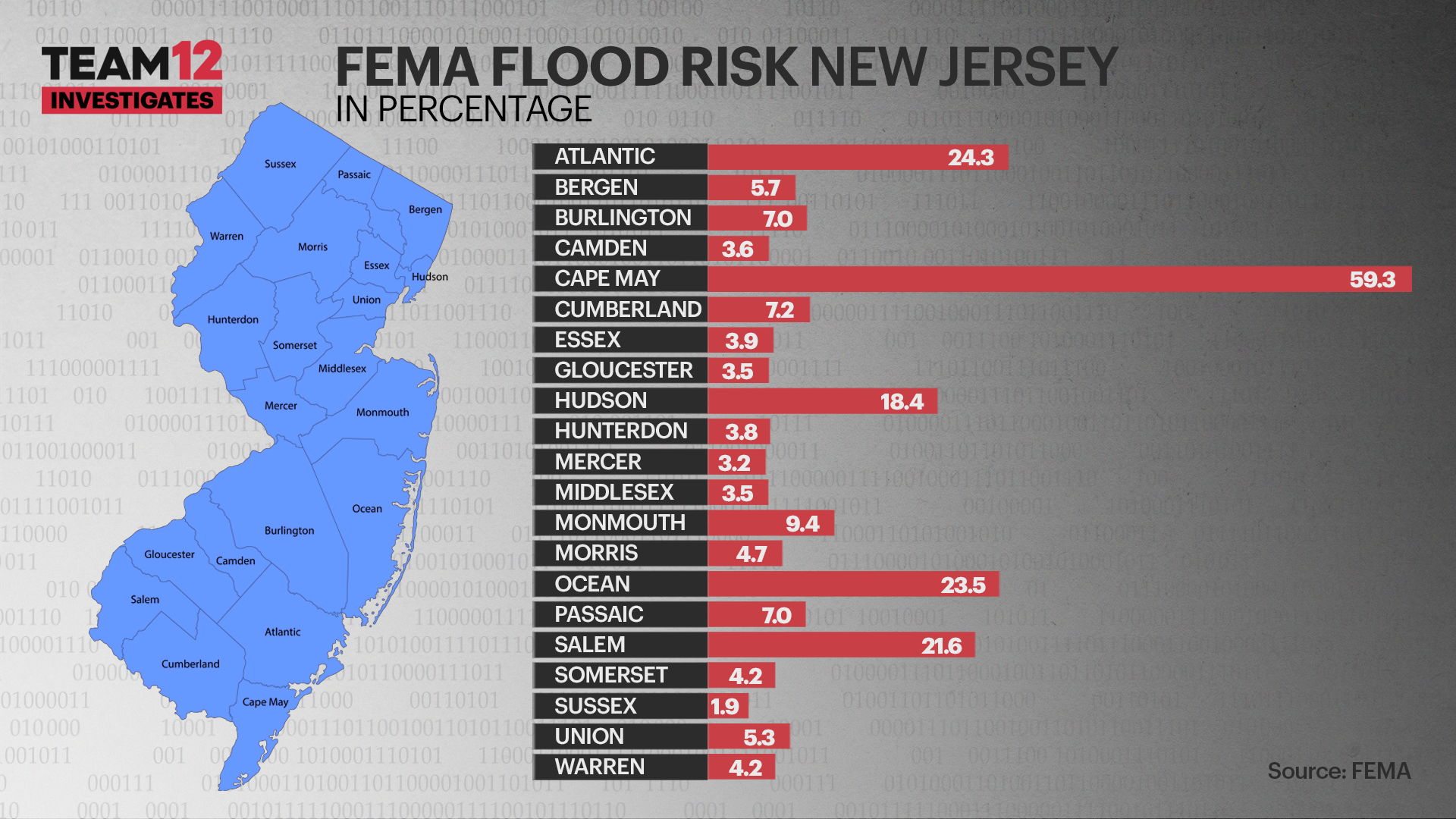
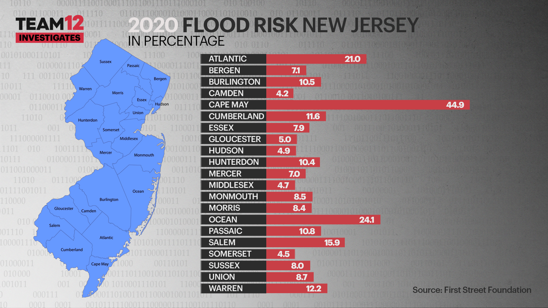
That’s getting harder to accomplish each year. A study by the First Street Foundation found one quarter of all critical infrastructure in America is now at operational risk from flooding. In the tristate area, the numbers are even higher: 26% in New Jersey, 33% in New York, and 35% in Connecticut.
The group found nearly 3,000 tri state area police departments, power plants and other critical facilities could have to stop operating during a flood event and nearly 55,000 miles of roadway could become impassable. Among the locations at extreme risk: LaGuardia Airport, used by 6.2 million people annually.
In Jersey City, which has been hit hard by flooding in recent years, Mayor Steve Fulop says his administration is working to prepare for the next flood, with measures like tougher construction standards and $1 billion in sewer improvements. But he says the city can’t do it on its own.
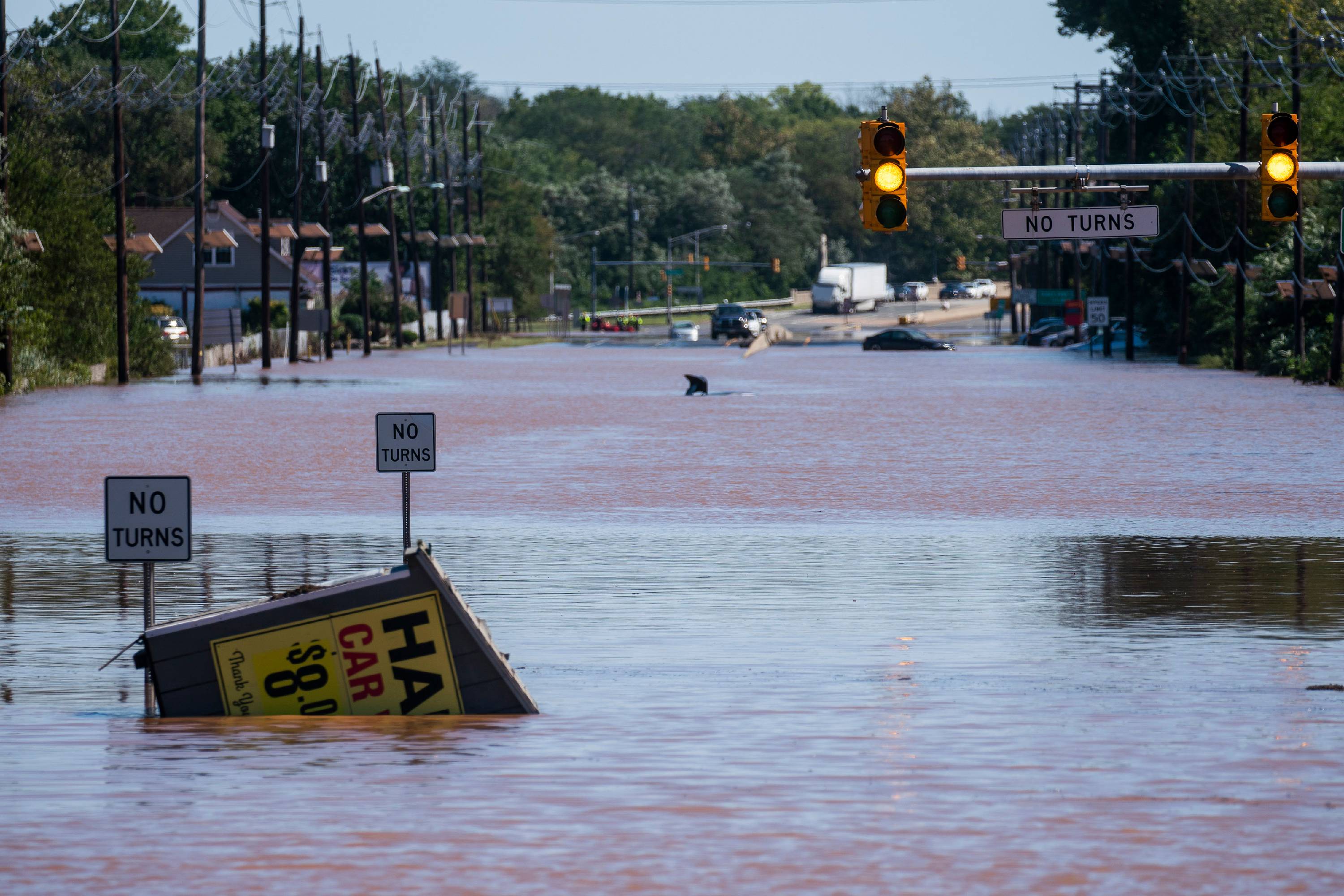
Cars and trucks are stranded by high water on the Major Deegan Expressway on Thursday Sept. 2, 2021, in the Bronx.(AP Photo/Craig Ruttle, File)
“We also need help at the federal level, because a lot of it is very expensive,” Fulop says.
The $1.2 trillion infrastructure bill recently passed by Congress could potentially provide some relief. It earmarks $47 billion for flood prevention, including $12 billion for flood control and dredging projects, and $3.5 billion to buy out or elevate homes in flood zones. It also could provide up to $10 billion for New York’s transit system, some of which would likely be used for waterproofing.
That could be welcome news for anyone who had to wade through dirty water over the summer, just to catch the train home.
FAILING FLOOD MAPS
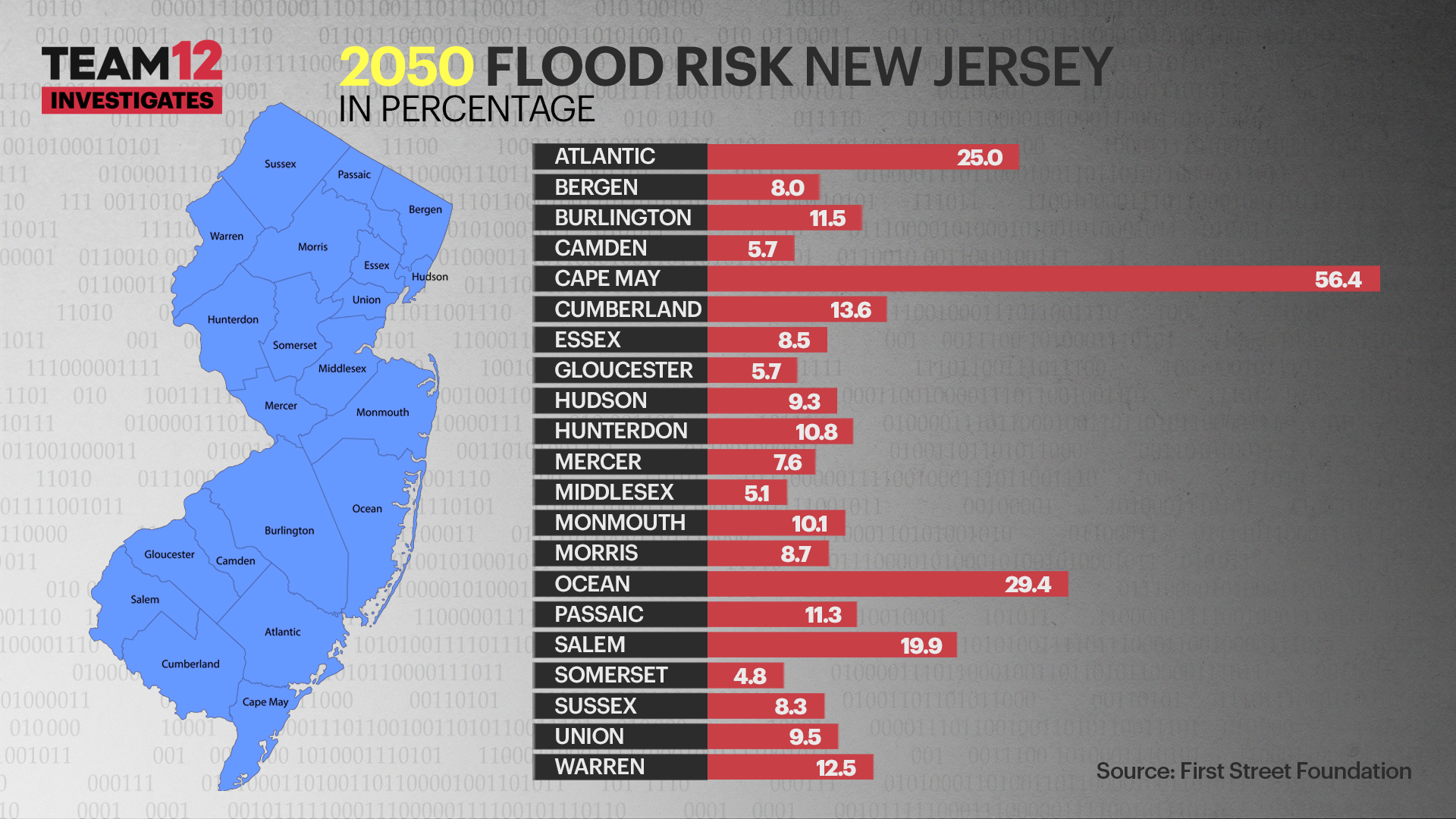
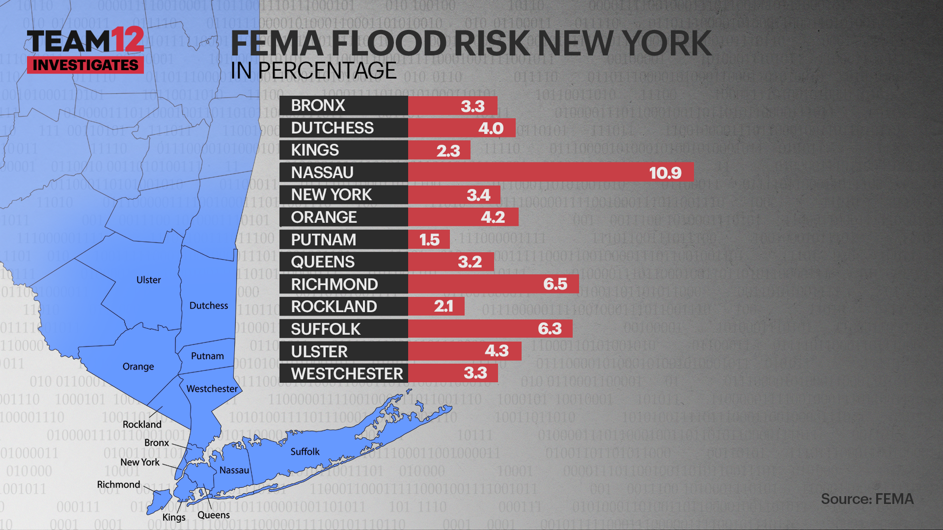
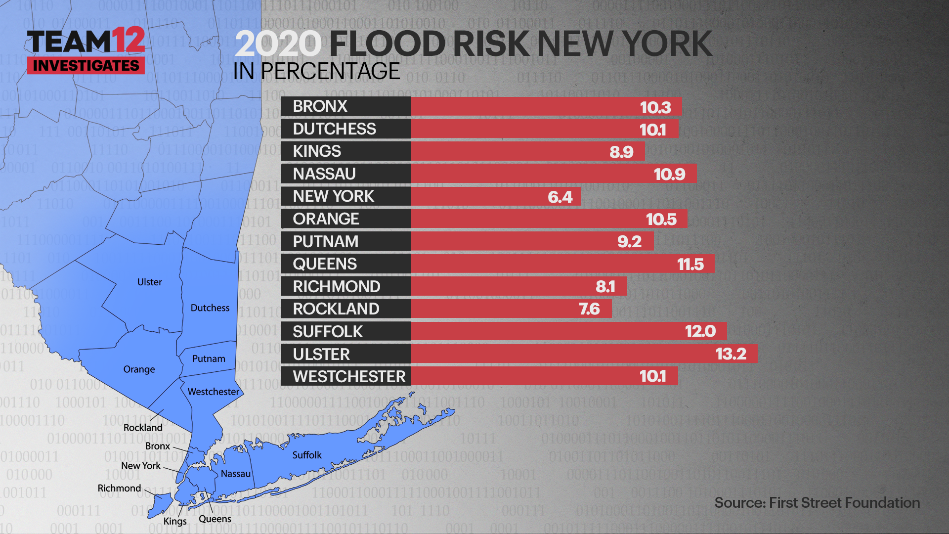
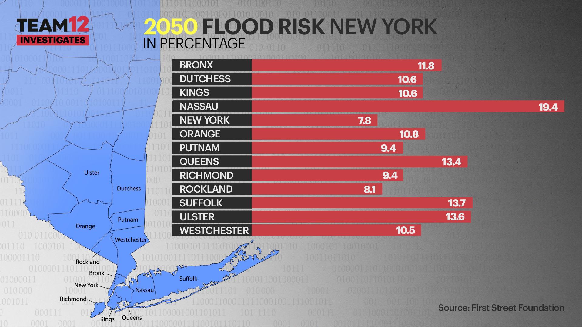
A Team 12 Investigation finds the government’s outdated flood maps, some of which have not been updated since the 1970s, give homeowners a distorted picture of flood risk, leaving some with huge bills for repairs that could have been covered by flood insurance. More accurate data is available, but many homeowners don’t know it exists.
Residents of the Rossmoor 55 and over community in Monroe, New Jersey, will never forget the day they were hit by the remnants of Ida.
INTERACTIVE FLOOD MAPS: Use the slider tool to compare FEMA 2020 information (left) vs. information from First Street Foundation (right) in the same area.
Bridgeport, Connecticut:
Great Neck, NY (Long Island)
Monroe, NJ:
“In a million years, I wouldn’t wish this on my worst enemy,” says Ann Wernick.
Her neighbor, Fran Klinsky, says this is her fourth severe flood. But they and many others in the community must now foot the bill for tens of thousands of dollars in repairs, with no help from insurance. According to the Federal Emergency Management Agency, their homes are not in a flood zone. As a result, they were not required to buy flood insurance, and they chose not to.
In a million years, I wouldn’t wish this on my worst enemy.
Klinsky says she bought a flood policy after a previous flood but let it lapse due to the cost. Wernick says she never got a policy because, “A lot of people told me, ‘you don't need it, it's not a flood zone’.”
It’s a story Senior Investigative Reporter Walt Kane heard repeatedly. From Greenwich, Connecticut, to Great Neck, New York homeowners complained of devastating floods in areas outside FEMA flood zones, meaning the agency says they should flood less than once a century.
Why is this happening? For one thing, Team 12 found the government relies on maps that may be decades old. FEMA’s last map update was in 2010, but the agency’s data shows some map panels were last updated as far back as 1974.
“A lot has changed in the last 50 years,” says Chad Berginnis of the Association of State Floodplain Managers. “We have this trend of increasing heavy rainfall events. And that data, when you put it into the models that produce the maps, create different maps.”
The First Street Foundation compared FEMA’s flood maps to areas that had experienced flooding events and found 5.9 million more properties at risk of flooding, 70% more than the FEMA maps show.
“When you don't account for that, then folks don't know that they have risk, and they don't have insurance,” says Jeremy Porter, First Street Foundation’s head of research and development.
The group also created an online tool, Flood Factor, that lets homeowners see their flood risk over the next 30 years. The data is available for free, but homeowners Team 12 talked to had not heard of it.
The differences in maps can be striking. FEMA’s map showed no flood zones in the part of Great Neck that experienced severe flooding; First Street’s model showed the entire neighborhood as a flood zone. In Monroe, FEMA’s map showed the flood zone ending long before it reached Klinsky or Wernick’s homes; First Street’s model showed much of the neighborhood at risk.
Congressional Democrats had proposed allocating $3 billion for new flood maps in the infrastructure bill, but the funding was cut from the final version.
“Some people have said for years that we can't afford to deal with climate change, it's too big a cost to our economy,” says Rep. Tom Malinowski, (D – New Jersey), a member of the House Transportation and Infrastructure Committee. “What we're realizing now is we can't afford not to.”
"A CATASTROPHE WAITING TO HAPPEN"
Rich Barrabi shows us how the United States ended up with its current infrastructure dilemma.
Aging bridges. Pothole-plagued roads. Swamped sewers. America's infrastructure needs significant repairs, according to the American Society of Civil Engineers.
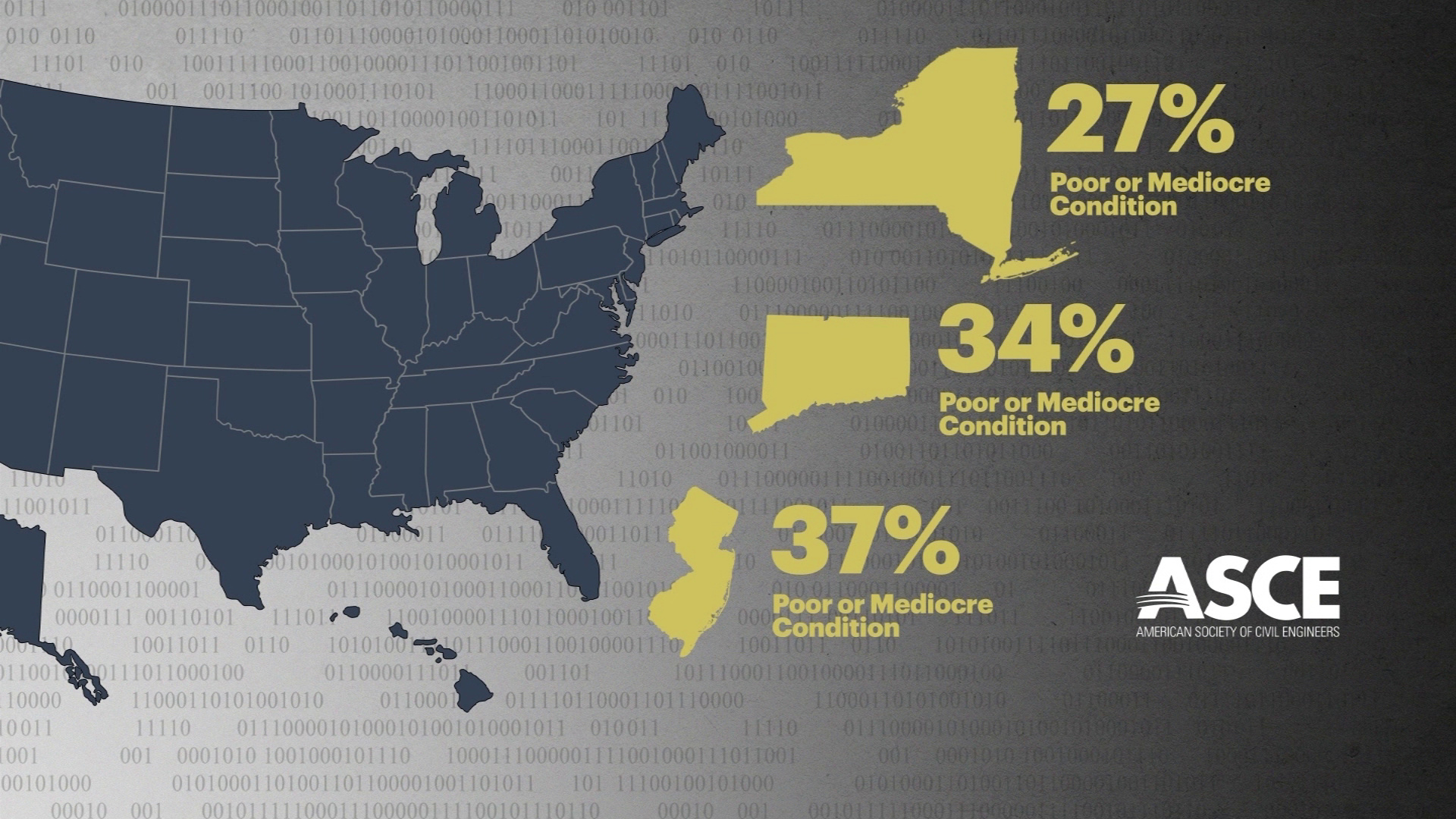
The ASCE finds that nationwide, 43% of our roadways are in poor or mediocre condition, including 27% in New York, 34% in Connecticut and 37% in New Jersey. In addition to that, 42% of all of our bridges are at least 50 years old and more than 46,000 are considered structurally deficient.
Roadway data from the Tri-State area, courtesy of ASCE.
VIDEO: A Better America - Library of Congress This video from the Library of Congress shows WPA projects being carried out on a nationwide level during the depression.
"I think we have neglected and disregarded these challenges because it was easier to put it off, procrastinate, delay. We can't do it anymore," says Senator Richard Blumenthal (D-Connecticut).
Sen. Blumenthal adds that it's 'a catastrophe waiting to happen.'
"To build and maintain infrastructure, you need three things. Money, vision, and willpower," says George Marlin, former CEO and Executive Director of the Port Authority of New York and New Jersey.
VIDEO: Road to Prosperity Federal Highway Administration video about the Interstate Highway System.
"What you need is a governor or a mayor to appoint a visionary who is above politics."
VIDEO: Building a Better New York - Library of Congress Library of Congress video showing WPA projects in New York State, including reservoir construction, improvement of parks and recreation facilities and employment of trained technicians and clerical workers for the Bureau of Criminal Investigation of the New York State Police.
Joseph Sabia, who has owned and operated Sabia's Car Care for nearly 50 years, blames elected leaders for the current state of our roads.
"Our infrastructure here is falling apart and the politicians just keep kicking the can down the road," Sabia says.
And while a pothole-plagued road may lead to more customers, Sabia says he would prefer that his neighbors and friends have the opportunity to drive on smooth and safe surfaces.
"It brings heartache, not business. You don't want that type of business."